8.5.1 Overview - LUPMISManual
Main menu:
- 0. Introduction
- 1. GIS handling
-
2. GIS data entry
- 2.1 Create new layer
- 2.2 Digitize line
- 2.3 Digitize point
- 2.4 Digitize polygon
- 2.5 Edit existing layer
- 2.6 Delete feature
- 2.7 Split line
- 2.8 Split polygon
- 2.9 Merge lines from different layers
- 2.10 Unite lines
- 2.11 Snap lines
- 2.12 Join polygons
- 2.13 Extend polygon
- 2.14 Insert island
- 2.15 Define unit surrounding islands
- 2.16 Create 'doughnut'
- 2.17 Fill 'doughnut' polygon
- 2.18 Fill polygon with 'holes'
- 2.19 Digitize parcels from sector layout
-
3. GIS operations
- 3.1 Create buffer
- 3.2 Create exclusion zone
- 3.3 Overlay units
- 3.4 Convert line to polygon
- 3.5 Derive statistics (area size, length)
- 3.6 Clip unit according to other unit
- 3.7 Create geographic grid
- 3.8 Move entire vector map
- 3.9 Move or copy individual features on a map
- 3.10 Adjust polygon to line
- 3.11 Convert points to polygon
- 3.12 Define by distance
- 3.13 Create multiple objects
- 3.14 Transfer styles from one layer to another
-
4. Attribute database
- 4.1 Start with database
- 4.2 Import database
- 4.3 Display database information
- 4.4 Enter attribute data
- 4.5 Attribute matrix of multiple layers
- 4.6 Seeds
- 4.7 Repair attribute data
- 4.8 Merge lines with attached database
- 4.9 Transfer attribute data from points to polygons
- 4.10 Copy styles, labels, attributes
-
5. Conversion of data
-
5.1 Points
- 5.1.1 Import list of points from text file
- 5.1.2 Import list of points from Excel file
- 5.1.3 Convert point coordinates between projections
- 5.1.4 Convert point coordinates from Ghana War Office (feet)
- 5.1.5 Convert point coordinates from Ghana Clark 1880 (feet)
- 5.1.6 Track with GPS
- 5.1.7 Download GPS track from Garmin
- 5.1.8 Download GPS track from PDA
- 5.1.9 Frequency analysis of points
- 5.2 Vector maps
- 5.3 Raster maps
-
5.4 Communication with other GIS programs
- 5.4.1 Import GIS data from SHP format
- 5.4.2 Import GIS data from E00 format
- 5.4.3 Import GIS data from AutoCAD
- 5.4.4 Export LUPMIS data to other programs
- 5.4.5 Export GIS to AutoCAD
- 5.4.6 Change a shape file to GPX
- 5.4.7 Transfer GIS data to other LUPMIS installations
- 5.4.8 Digitize lines in Google Earth
- 5.5 Terrain data
- 5.6 Export to tables
- 5.7 Density map
-
5.1 Points
-
6. Presentation
- 6.1 Labels
- 6.2 Styles and Symbols
- 6.3 Marginalia
- 6.4 Legend
- 6.5 Map template
- 6.6 Final print
- 6.7 Print to file
- 6.8 3D visualization
- 6.9 External display of features
- 6.10 Google
-
7. GIS for land use planning
- 7.1 Introduction to land use planning
- 7.2 Land use mapping for Structure Plan
- 7.3 Detail mapping for Local Plan
- 7.4 Framework
- 7.5 Structure Plan
- 7.6 Local Plan
- 7.7 Follow-up plans from Local Plan
- 7.8 Land evaluation
-
8. LUPMIS Tools
- 8.1 General
- 8.2 Drawing Tools
-
8.3 Processing Tools
- 8.3.1 UPN
- 8.3.2 Streetname + housenumbers
- 8.3.3 Address Database + tools
- 8.3.4 Format conversion
- 8.3.5 Coordinate system conversion
- 8.3.6 Raster processing
- 8.3.7 Altitude/DTM
- 8.3.8 Other GIS Tools
- 8.3.9 Utilities
- 8.4 Printing Tools
-
8.5 Permit Tools
- 8.5.1 Overview
- 8.5.2 Entry
- 8.5.3 Applicants
- 8.5.4 Parcels
- 8.5.5 Permits
- 8.5.6 Permit Database management
- 8.5.7 Notes for Permit Database
- 8.6 Census Tools
-
8.7 Revenue Tools
- 8.7.1 Overview
- 8.7.2 Entry of revenue data
- 8.7.3 Retrieval of revenue data
- 8.7.4 Revenue maps
- 8.7.5 Other revenue tools
- 8.8 Reports Tools
- 8.9 Settings
-
9. Databases
- 9.1 Permit Database
-
9.2 Plans
- 9.2.1 Accra
- 9.2.2 Kasoa
- 9.2.3 Dodowa
- 9.2.4 Sekondi-Takoradi
-
9.3 Census Database
-
9.4 Revenue Database
-
9.5 Report Database
-
9.6 Project Database
- 9.7 Address Database
-
Annexes 1-10
- A1. LUPMIS setup
- A2. Background to cartography/raster images
- A3. Glossary, index
- A4. Troubleshooting
- A5. Styles
- A6. Classification for landuse mapping/planning
- A7. GIS utilities
- A8. Map projection parameters
- A9. Regions / Districts
- A10. Standards
-
Annexes 11-20
- A11. LUPMIS distribution
- A12. Garmin GPS
- A13. Training
- A14. ArcView
- A15. Population statistics
- A16. Entry and display of survey data
- A17. External exercises
- A18. Programming
- A19. Paper sizes
- A20. Various IT advices
- A21. Contact, references
8.5 Permit Tools
Level of expertise required for this Chapter: Intermediate; specifically for LUPMIS @ TCPD
Note: Features described below are not part of standard Map Maker. They have been developed at LUPMP in Ghana to handle parcels at Local Plan level (Planning Permit, Building Permit, drawing of parcels). For external technical inquiries, feel free to contact us ( email).
Land use planning is primarily the formulation of plans at different levels (scales and detail), i.e. the collection and compilation of data, preparation of the 'best options' for future land uses and selection of the optimal land use in a political process with involvement of all parties in a legal setting.
The process of issuing permits for the implementation of land use plans is a well-defined 'business' process, not like the ‘creative’ formulation of plans. Permits form part of the land administration, where land sector agencies have their individual mandates and information systems (only to mention: LIS, GELIS, CSAU, UMLIS).
- Planning Permits allow the applicant to develop the land (parcel) according to the Structure Plan and Local Plan. These plans define land use zones, which legally allow, prohibit or restrict specified land uses. The Planning Permit gives the right to use land accordingly, for example to build a residence, a warehouse, a hotel.
- Building Permits allow the applicant to build a structure ('building') with well-defined dimensions, functions, access. The primary purposes are the structural integrity and health, engineering and sanitation aspects. It has to be based on the Planning Permit (which again is based on the Structure Plan and Local Plan), but includes more detailed features, to be approved by engineers and architects.
The Permit Database serves three functions:
A) In combination of DBMS and GIS data, it works as a production tool to generate, monitor, print and map permits.
Application number
Date of application
Approval status
Object of request
Name of applicant
Etc
C) It works as a quality control (QC) tool for GIS data, particularly for Local Plan maps. This includes checks for:
Redundancy of UPN
Completeness
Topology cleanness
Etc
- - - - -
In technical terms, it is built on a robust, transparent technology, which – as the highest goal of sustainability and technology transfer – can be easily installed and taught both on a user and future developers level.
- - - -
Following assumptions are made for the Permit Database:
a) One person can apply on more than one parcel (for example, owner of multiple parcels).
b) One or more persons can apply for a parcel. One permit will be issued, no matter if one or more persons applied, i.e. one applicant and possibly one co-applicant.
c) An applicant can be supported by an agent.
d) One Planning Permit can be requested and granted for more than one parcel (for example, estate development permit).
e) Only one Planning Permit can be applied for a parcel, not multiple Planning Permits.
f) All parcels should follow the UPN system.
g) The LUPMIS - Permit Database is an inventory system, not a legal official instrument (at this stage).
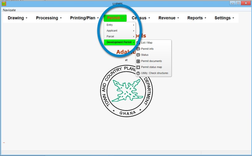
h) The only legal documents are hardcopy permits, issued by TCPD, signed and stamped by an authorized person. These can be printed from LUPMIS (Permit Tools > Development Permit > Permit (document)).
i) Scanning of legal hardcopy documents (either of the past or current) is supported by the LUPMIS-Permit Database.
j) The process of issuing of Planning Permits, as granted by TCPD, does not confirm proof of ownership on the applicant.
- - - - -
Database design:
The Permit Database consists of four main data tables ('A-tables') containing information about:
Parcels
Applicants
Permits

