8.3.8.1 Quality-control - LUPMISManual
Main menu:
×
- 0. Introduction
- 1. GIS handling
-
2. GIS data entry
- 2.1 Create new layer
- 2.2 Digitize line
- 2.3 Digitize point
- 2.4 Digitize polygon
- 2.5 Edit existing layer
- 2.6 Delete feature
- 2.7 Split line
- 2.8 Split polygon
- 2.9 Merge lines from different layers
- 2.10 Unite lines
- 2.11 Snap lines
- 2.12 Join polygons
- 2.13 Extend polygon
- 2.14 Insert island
- 2.15 Define unit surrounding islands
- 2.16 Create 'doughnut'
- 2.17 Fill 'doughnut' polygon
- 2.18 Fill polygon with 'holes'
- 2.19 Digitize parcels from sector layout
-
3. GIS operations
- 3.1 Create buffer
- 3.2 Create exclusion zone
- 3.3 Overlay units
- 3.4 Convert line to polygon
- 3.5 Derive statistics (area size, length)
- 3.6 Clip unit according to other unit
- 3.7 Create geographic grid
- 3.8 Move entire vector map
- 3.9 Move or copy individual features on a map
- 3.10 Adjust polygon to line
- 3.11 Convert points to polygon
- 3.12 Define by distance
- 3.13 Create multiple objects
- 3.14 Transfer styles from one layer to another
-
4. Attribute database
- 4.1 Start with database
- 4.2 Import database
- 4.3 Display database information
- 4.4 Enter attribute data
- 4.5 Attribute matrix of multiple layers
- 4.6 Seeds
- 4.7 Repair attribute data
- 4.8 Merge lines with attached database
- 4.9 Transfer attribute data from points to polygons
- 4.10 Copy styles, labels, attributes
-
5. Conversion of data
-
5.1 Points
- 5.1.1 Import list of points from text file
- 5.1.2 Import list of points from Excel file
- 5.1.3 Convert point coordinates between projections
- 5.1.4 Convert point coordinates from Ghana War Office (feet)
- 5.1.5 Convert point coordinates from Ghana Clark 1880 (feet)
- 5.1.6 Track with GPS
- 5.1.7 Download GPS track from Garmin
- 5.1.8 Download GPS track from PDA
- 5.1.9 Frequency analysis of points
- 5.2 Vector maps
- 5.3 Raster maps
-
5.4 Communication with other GIS programs
- 5.4.1 Import GIS data from SHP format
- 5.4.2 Import GIS data from E00 format
- 5.4.3 Import GIS data from AutoCAD
- 5.4.4 Export LUPMIS data to other programs
- 5.4.5 Export GIS to AutoCAD
- 5.4.6 Change a shape file to GPX
- 5.4.7 Transfer GIS data to other LUPMIS installations
- 5.4.8 Digitize lines in Google Earth
- 5.5 Terrain data
- 5.6 Export to tables
- 5.7 Density map
-
5.1 Points
-
6. Presentation
- 6.1 Labels
- 6.2 Styles and Symbols
- 6.3 Marginalia
- 6.4 Legend
- 6.5 Map template
- 6.6 Final print
- 6.7 Print to file
- 6.8 3D visualization
- 6.9 External display of features
- 6.10 Google
-
7. GIS for land use planning
- 7.1 Introduction to land use planning
- 7.2 Land use mapping for Structure Plan
- 7.3 Detail mapping for Local Plan
- 7.4 Framework
- 7.5 Structure Plan
- 7.6 Local Plan
- 7.7 Follow-up plans from Local Plan
- 7.8 Land evaluation
-
8. LUPMIS Tools
- 8.1 General
- 8.2 Drawing Tools
-
8.3 Processing Tools
- 8.3.1 UPN
- 8.3.2 Streetname + housenumbers
- 8.3.3 Address Database + tools
- 8.3.4 Format conversion
- 8.3.5 Coordinate system conversion
- 8.3.6 Raster processing
- 8.3.7 Altitude/DTM
- 8.3.8 Other GIS Tools
- 8.3.9 Utilities
- 8.4 Printing Tools
-
8.5 Permit Tools
- 8.5.1 Overview
- 8.5.2 Entry
- 8.5.3 Applicants
- 8.5.4 Parcels
- 8.5.5 Permits
- 8.5.6 Permit Database management
- 8.5.7 Notes for Permit Database
- 8.6 Census Tools
-
8.7 Revenue Tools
- 8.7.1 Overview
- 8.7.2 Entry of revenue data
- 8.7.3 Retrieval of revenue data
- 8.7.4 Revenue maps
- 8.7.5 Other revenue tools
- 8.8 Reports Tools
- 8.9 Settings
-
9. Databases
- 9.1 Permit Database
-
9.2 Plans
- 9.2.1 Accra
- 9.2.2 Kasoa
- 9.2.3 Dodowa
- 9.2.4 Sekondi-Takoradi
-
9.3 Census Database
-
9.4 Revenue Database
-
9.5 Report Database
-
9.6 Project Database
- 9.7 Address Database
-
Annexes 1-10
- A1. LUPMIS setup
- A2. Background to cartography/raster images
- A3. Glossary, index
- A4. Troubleshooting
- A5. Styles
- A6. Classification for landuse mapping/planning
- A7. GIS utilities
- A8. Map projection parameters
- A9. Regions / Districts
- A10. Standards
-
Annexes 11-20
- A11. LUPMIS distribution
- A12. Garmin GPS
- A13. Training
- A14. ArcView
- A15. Population statistics
- A16. Entry and display of survey data
- A17. External exercises
- A18. Programming
- A19. Paper sizes
- A20. Various IT advices
- A21. Contact, references
8. LUPMIS Tools > 8.3 Processing Tools > 8.3.8 Other GIS Tools
8.3.8.1 Quality-Control
Level of expertise required for this Chapter: Advanced; specifically for LUPMIS @ TCPD
Automatic check of following features are made for GIS files:
- Feature types (should contain only polygons or lines or points or text, but not a combination of those)
- Local Plans should have only polygons
- Invalid labels or ids
- Plans should have a planning zone (style)
- Streetlines should have unique names and not be broken
- Local Plans should have a UPN
- Coordinate system should be valid (GTM or UTM)
- No duplicate features should exist
- No micro polygons or micro gaps should exist in polygon maps
- Vertex points should be snapped in polygon maps
- Local Plans should have an address (street name and property number)
- Local Plans should not have more than 6000 parcels
- Detection of label points in polygon maps, which are outside of the polygon
- Identification of polygons, which are not correctly 'snapped' and form overlapping or missing areas (semi-automatic)
- Complete with addresses (for Local Plans)
- Complete with UPN (for Local Plans)
- Complete with planning zones (for Local Plans)
This QC check can be invoked through Processing Tools > Other GIS Tools > Quality-control of GIS file > Select file > Select type of check (there are basic and complete tests) > Execute:
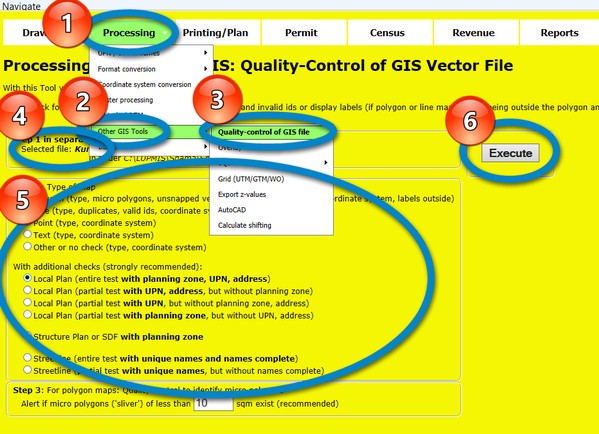
The check will either show failure:
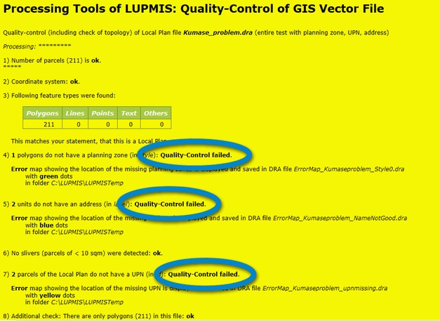
or passing:

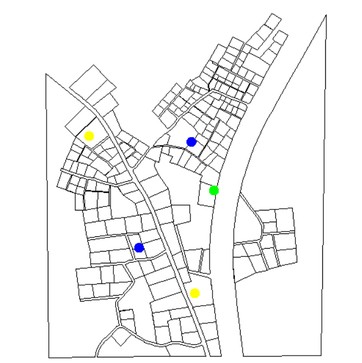
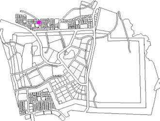
To show the location and easy fix, 'Error maps' are generated at the end of the quality-control process, with dots either in the centre of a feature or at the polygon boundary (actually, 1.vertex) of the failed parcel.
Different colours (in different GIS files) indicate the problems. For example:
Different colours (in different GIS files) indicate the problems. For example:
- Brown: Small sliver polygons
- Red: Wrong features (e.g. lines in a polygon map)
- Green: Missing planning zone (style)
- Blue: Missing address/street name
- Yellow: Missing UPN
- Purple: Micro polygons
- Magenta: Labels outside polygons