LUPMIS - GIS User Manual for Land Use Planning
Main menu:
- Home Page
- 0. Rationale
- 1. GIS handling
- 2. GIS data entry
- 2.1 Create new layer
- 2.2 Digitize line
- 2.3 Digitize point
- 2.4 Digitize polygon
- 2.5 Edit existing layer
- 2.6 Delete feature
- 2.7 Split line
- 2.8 Split polygon
- 2.9 Merge lines from different layers
- 2.10 Unite lines
- 2.11 Snap lines
- 2.12 Join polygons
- 2.13 Extend polygon
- 2.14 Insert island
- 2.15 Define unit surrounding islands
- 2.16 Create 'doughnut'
- 2.17 Fill 'doughnut' polygon
- 2.18 Fill polygon with 'holes'
- 2.19 Digitize parcels from sector layout
- 3. GIS operations
- 3.1 Create buffer
- 3.2 Create exclusion zone
- 3.3 Overlay units
- 3.4 Convert line to polygon
- 3.5 Derive statistics (area size, length)
- 3.6 Clip unit according to other unit
- 3.7 Create geographic grid
- 3.8 Move entire vector map
- 3.9 Move or copy individual features on a map
- 3.10 Adjust polygon to line
- 3.11 Convert points to polygon
- 3.12 Define by distance
- 3.13 Create multiple objects
- 4. Attribute database
- 4.1 Start with database
- 4.2 Import database
- 4.3 Display database information
- 4.4 Enter attribute data
- 4.5 Attribute matrix of multiple layers
- 4.6 Seeds
- 4.7 Repair attribute data
- 4.8 Merge lines with attached database
- 4.9 Transfer attribute data from points to polygons
- 4.10 Copy styles, labels, attributes
- 5. Conversion of data
- 5.1 Points
- 5.1.1 Import list of points from text file
- 5.1.2 Import list of points from Excel file
- 5.1.3 Convert point coordinates between projections
- 5.1.4 Convert point coordinates from Ghana War Office (feet)
- 5.1.5 Convert point coordinates from Ghana Clark 1880 (feet)
- 5.1.6 Track with GPS
- 5.1.7 Download GPS track from Garmin
- 5.1.8 Download GPS track from PDA
- 5.2 Vector maps
- 5.3 Raster maps
- 5.4 Communication with other GIS programs
- 5.4.1 Import GIS data from SHP format
- 5.4.2 Import GIS data from E00 format
- 5.4.3 Import GIS data from AutoCAD
- 5.4.4 Export LUPMIS data to other programs
- 5.4.5 Export GIS to AutoCAD
- 5.4.6 Change a shape file to GPX
- 5.4.7 Transfer GIS data to other LUPMIS installations
- 5.4.8 Digitize lines in Google Earth
- 5.5 Drawing Tools
- 5.6 Terrain data
- 5.1 Points
- 6. Presentation
- 7. GIS for land use planning
- 8. Database
- Annexes
- A1. Map Maker setup
- A2. Background to cartography and raster images
- A3. Glosssary
- A4. Troubleshooting
- A5. Styles
- A6. Classification for land use mapping and planning
- A7. GIS utilities
- A8. Map projection parameters
- A9. Maps in pilot areas
- A10.Standards
- A11. LUPMIS distribution CD
- A12. Garmin GPS
- A13. Training
- A14. ArcView
- A15. Population statistics
- A16. Entry and display of survey data
- A17. External exercises
- A18. MS Access
- A19. Paper sizes
- A20. Site map and references
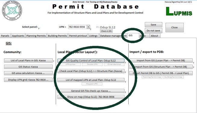
8.1.3 QC of GIS
8. Database > 8.1 Permit Database
8.1.3 QC of GIS
Level of expertise required for this Chapter: Intermediate
In an automatic procedure following GIS characteristics are checked:
- Unique occurrence of all UPN: No UPN should be mapped more than once
- All units are correct polygons: There are no points, no lines, no polygons with an area of 0
- All parcels have a UPN
- Correct installation of LUPMIS and Map Maker
- Correct location of the Local Plan DRA file
- Correct spelling of the Local Plan DRA file
- Check for duplicate objects, offer to delete duplicated objects in the DRA file (see also Part I of Chapter 8.1.5).
- Check for correct syntax of all UPN (xxx-yyyy-nnnn, see Chapter 7.8.1)
- Existence of selected parcel in the Local Plan DRA file
- Identity of display labels and IDs in the DRA file (see part G of Chapter 8.1.5 and standards in Annex 10).
If any of these conditions fail, an error message is shown. A list of the faulty parcels can be displayed (active buttons under QC: GIS).
- - - - -
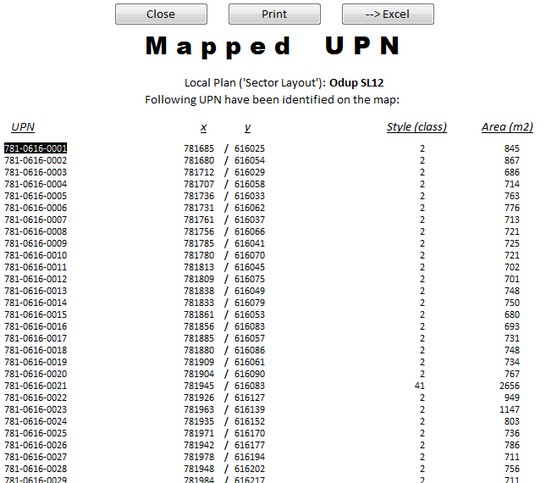
It is also possible to display a list of all mapped parcel (mapped UPN) in the DRA file:
It is possible and for some operations necessary to import data, which are in the DRA file, to the Permit Database, such as the land use planning zone (in style), the precise location (x and y), the size of the parcel etc. These data are automatically integrated to the main data table of parcels through the Import from GIS (Local Plan --> PDB) button.
Similarly, also the more general land use planning zone of the Structure Plan can be imported to the Permit Database (through the Import from GIS (Structure Plan --> PDB) button (see also Part H of Chapter 8.1.5).
From there, data can be exported to the GIS to generate a map in Map Maker, either the status of the Planning Permits in this sector or of the Building Permits through Export Permit Database to GIS. See example below:
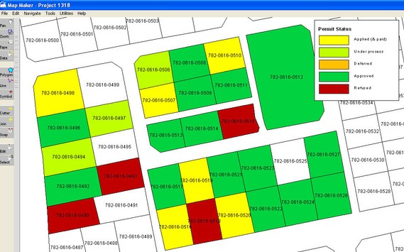
The legend can be called as map furniture from C:\LUPMIS\Permits\Support\Permitstatusmap_legend.emf. See Chapter 6.3.1 for the procedure to call and place map furniture.
These permits maps work as a perfect tool for monitoring the application status of a sector.
- - - - -
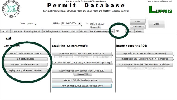
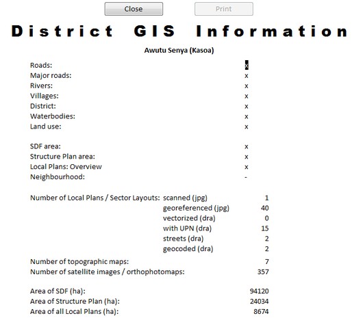
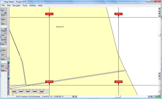
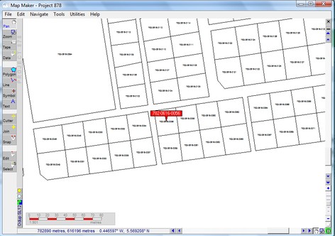
Additional listing features show information of GIS-established communities, UPN grid for UPN assignments, and location of a specified UPN parcel (samples below):
- - - - -
- - - - -


Sub-Menu: