8.5.6 Permit Database management - LUPMISManual
Main menu:
- 0. Introduction
- 1. GIS handling
-
2. GIS data entry
- 2.1 Create new layer
- 2.2 Digitize line
- 2.3 Digitize point
- 2.4 Digitize polygon
- 2.5 Edit existing layer
- 2.6 Delete feature
- 2.7 Split line
- 2.8 Split polygon
- 2.9 Merge lines from different layers
- 2.10 Unite lines
- 2.11 Snap lines
- 2.12 Join polygons
- 2.13 Extend polygon
- 2.14 Insert island
- 2.15 Define unit surrounding islands
- 2.16 Create 'doughnut'
- 2.17 Fill 'doughnut' polygon
- 2.18 Fill polygon with 'holes'
- 2.19 Digitize parcels from sector layout
-
3. GIS operations
- 3.1 Create buffer
- 3.2 Create exclusion zone
- 3.3 Overlay units
- 3.4 Convert line to polygon
- 3.5 Derive statistics (area size, length)
- 3.6 Clip unit according to other unit
- 3.7 Create geographic grid
- 3.8 Move entire vector map
- 3.9 Move or copy individual features on a map
- 3.10 Adjust polygon to line
- 3.11 Convert points to polygon
- 3.12 Define by distance
- 3.13 Create multiple objects
- 3.14 Transfer styles from one layer to another
-
4. Attribute database
- 4.1 Start with database
- 4.2 Import database
- 4.3 Display database information
- 4.4 Enter attribute data
- 4.5 Attribute matrix of multiple layers
- 4.6 Seeds
- 4.7 Repair attribute data
- 4.8 Merge lines with attached database
- 4.9 Transfer attribute data from points to polygons
- 4.10 Copy styles, labels, attributes
-
5. Conversion of data
-
5.1 Points
- 5.1.1 Import list of points from text file
- 5.1.2 Import list of points from Excel file
- 5.1.3 Convert point coordinates between projections
- 5.1.4 Convert point coordinates from Ghana War Office (feet)
- 5.1.5 Convert point coordinates from Ghana Clark 1880 (feet)
- 5.1.6 Track with GPS
- 5.1.7 Download GPS track from Garmin
- 5.1.8 Download GPS track from PDA
- 5.1.9 Frequency analysis of points
- 5.2 Vector maps
- 5.3 Raster maps
-
5.4 Communication with other GIS programs
- 5.4.1 Import GIS data from SHP format
- 5.4.2 Import GIS data from E00 format
- 5.4.3 Import GIS data from AutoCAD
- 5.4.4 Export LUPMIS data to other programs
- 5.4.5 Export GIS to AutoCAD
- 5.4.6 Change a shape file to GPX
- 5.4.7 Transfer GIS data to other LUPMIS installations
- 5.4.8 Digitize lines in Google Earth
- 5.5 Terrain data
- 5.6 Export to tables
- 5.7 Density map
-
5.1 Points
-
6. Presentation
- 6.1 Labels
- 6.2 Styles and Symbols
- 6.3 Marginalia
- 6.4 Legend
- 6.5 Map template
- 6.6 Final print
- 6.7 Print to file
- 6.8 3D visualization
- 6.9 External display of features
- 6.10 Google
-
7. GIS for land use planning
- 7.1 Introduction to land use planning
- 7.2 Land use mapping for Structure Plan
- 7.3 Detail mapping for Local Plan
- 7.4 Framework
- 7.5 Structure Plan
- 7.6 Local Plan
- 7.7 Follow-up plans from Local Plan
- 7.8 Land evaluation
-
8. LUPMIS Tools
- 8.1 General
- 8.2 Drawing Tools
-
8.3 Processing Tools
- 8.3.1 UPN
- 8.3.2 Streetname + housenumbers
- 8.3.3 Address Database + tools
- 8.3.4 Format conversion
- 8.3.5 Coordinate system conversion
- 8.3.6 Raster processing
- 8.3.7 Altitude/DTM
- 8.3.8 Other GIS Tools
- 8.3.9 Utilities
- 8.4 Printing Tools
-
8.5 Permit Tools
- 8.5.1 Overview
- 8.5.2 Entry
- 8.5.3 Applicants
- 8.5.4 Parcels
- 8.5.5 Permits
- 8.5.6 Permit Database management
- 8.5.7 Notes for Permit Database
- 8.6 Census Tools
-
8.7 Revenue Tools
- 8.7.1 Overview
- 8.7.2 Entry of revenue data
- 8.7.3 Retrieval of revenue data
- 8.7.4 Revenue maps
- 8.7.5 Other revenue tools
- 8.8 Reports Tools
- 8.9 Settings
-
9. Databases
- 9.1 Permit Database
-
9.2 Plans
- 9.2.1 Accra
- 9.2.2 Kasoa
- 9.2.3 Dodowa
- 9.2.4 Sekondi-Takoradi
-
9.3 Census Database
-
9.4 Revenue Database
-
9.5 Report Database
-
9.6 Project Database
- 9.7 Address Database
-
Annexes 1-10
- A1. LUPMIS setup
- A2. Background to cartography/raster images
- A3. Glossary, index
- A4. Troubleshooting
- A5. Styles
- A6. Classification for landuse mapping/planning
- A7. GIS utilities
- A8. Map projection parameters
- A9. Regions / Districts
- A10. Standards
-
Annexes 11-20
- A11. LUPMIS distribution
- A12. Garmin GPS
- A13. Training
- A14. ArcView
- A15. Population statistics
- A16. Entry and display of survey data
- A17. External exercises
- A18. Programming
- A19. Paper sizes
- A20. Various IT advices
- A21. Contact, references
8.5.6 Permit Database Management

There are various tools to administer the Permit Database and to use it for quality-control.
- a) Check Structures:
1. Copy your Local Plan file to file (LocalPlan)_checkstructures.dra (e.g. Bogoso_checkstructures.dra)
in folder C:\LUPMIS\(district)\(district) LP\Tools.
2. In Map Maker, load this file in live layer.4. Load orthophotomap in the background.3. Ensure, that all styles are set to 0:
Project manager > Live layer actions > Basic operations > Set all objects to one style > OK > 0 > OK.
5. Colour outline of the parcels to yellow: Project manager > Project style set > Style management > Import style set and overwrite > Select 'Revenue outline' > Ok.6. Assign style 1 to each parcel, where you can see a structure / building / property.You can do this individually by: (Left) Edit > Click on parcel > Styles > 1 > OK,or alternatively, faster: Select > Click on parcel > With Ctrl click on the next parcel > Repeat for each parcel with structure ... > Edit > Show Selection Manager > Actions > Basic Operations > Set all objects to one style > 1 > OK.7. Dont forget to save at the end.The process may take an hour or two working in Map Maker.

- b) Backup and Export:
Backup the Permit Database (Settings Tools > Backup > Backup database) and the GIS (Settings Tools > Backup > Backup GIS + database).
Export the Permit Database (Settings Tools > Backup > Backup database) or the Local Plan with UPN and addresses (Settings Tools > Backup > Backup GIS + database) for import at other databases of Land Sector Agencies, such as GELIS or CSAU. Exported data are in standard exchange format (see also Chapter 8.4.6). Additional formats can be implemented on request of the Agencies.
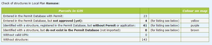
- c) Statistics and Monitoring:
Derive a statistics sheet with the number of records in the database (Settings Tools > Database statistics).
View a history (log file) of all processes transformed either on the Permit Database or on a particular parcel (Settings Tools > Monitoring).

