LUPMIS
Main menu:
- Home Page
- 1. Background and time frame
- 2. Community Orientation and GIS
- 3. Expected IS activities and output
- 4. Sites of installation and communications
- 5. Data sharing with other LSAs
- 6. Network
- 7. Software
- 8. Human resources and training
- 9. Work activities
- 10. Conclusions and future IS developments
- Annexes
- Annex 1: Projection and datum
- Annex 2: Procurement plan
- Annex 3: Justification of procurement items
- Annex 4: Standards
- Annex 5: Possible scenarios of GIS analyses for land use planning
- Annex 6: DBMS for permits
- Annex 7: GPS mapping
- Annex 8: Data request for GIS
- Annex 9: Financial considerations
- Annex 10: Land use planning activities with IS
- Annex 11: Planning chart: Tasks
- Annex 12: Work programme: Tasks
- Annex 13: Pilot communities
- Annex 14: Coverage of orthophotos for LAP
- Annex 15: Training content
- Annex 16: Glossary
Annex 10: Land use planning activities with IS
Annexes
Annex 10: Land Use Planning Activities with IS
A systematic chart of TCPD activities, primarily for land use planning, from the data handling point of view, is shown below:
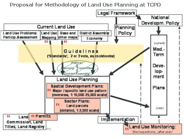
Figure A10.1: Land use planning activities with IS
IS stands for activities, where the Information System contributes, and which requires GIS / LIS support.
More conceptual work has to be done in the fields of financial sustainability, sharing of data and mandate with other LSAs, land use monitoring (see also Annex A5.4), QC an coordination of District activities by Regions, and after-plan actions (acquire land, compensation pay, implement physical structures, facilitate individual structures)
Copyright @ TCPD / LUPMP - version 2.0
Sub-Menu:
- Annex 1: Projection and datum
- Annex 2: Procurement plan
- Annex 3: Justification of procurement items
- Annex 4: Standards
- Annex 5: Possible scenarios of GIS analyses for land use planning
- Annex 6: DBMS for permits
- Annex 7: GPS mapping
- Annex 8: Data request for GIS
- Annex 9: Financial considerations
- Annex 10: Land use planning activities with IS ←
- Annex 11: Planning chart: Tasks
- Annex 12: Work programme: Tasks
- Annex 13: Pilot communities
- Annex 14: Coverage of orthophotos for LAP
- Annex 15: Training content
- Annex 16: Glossary