LUPMIS
Main menu:
- Home Page
- 1. Background and time frame
- 2. Community Orientation and GIS
- 3. Expected IS activities and output
- 4. Sites of installation and communications
- 5. Data sharing with other LSAs
- 6. Network
- 7. Software
- 8. Human resources and training
- 9. Work activities
- 10. Conclusions and future IS developments
- Annexes
- Annex 1: Projection and datum
- Annex 2: Procurement plan
- Annex 3: Justification of procurement items
- Annex 4: Standards
- Annex 5: Possible scenarios of GIS analyses for land use planning
- Annex 6: DBMS for permits
- Annex 7: GPS mapping
- Annex 8: Data request for GIS
- Annex 9: Financial considerations
- Annex 10: Land use planning activities with IS
- Annex 11: Planning chart: Tasks
- Annex 12: Work programme: Tasks
- Annex 13: Pilot communities
- Annex 14: Coverage of orthophotos for LAP
- Annex 15: Training content
- Annex 16: Glossary
Annex 7: GPS mapping
Annexes
Annex 7: GPS Mapping
The preferred way of mapping applying new technologies is done with GPS. There are various devices using GPS technology:
A6.1) Handheld GPS
They are robust, easy to handle, cheap, can transfer collected points to the PC (GIS) with some limitations.
Disadvantage is the impossibility to have a raster map (e.g. orthophoto) as a background. Third party software can not be installed.
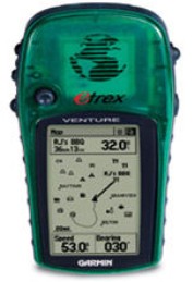
Figure A7.1: Handheld GPS
A6.2) PDA with GPS
Handheld computers (or pocket PCs or Personal Digital Assistants, PDAs) are more flexible and can be used for many purposes. They have an operating system installed (e.g. Windows Mobile 6), many PC programs have versions for PDA pocket version), data can be synchronized between PC and PDA. This higher flexibility results in greater complexity; a learning curve is required even for PC literates.
Large number of software for tracking exists and can be downloaded from the internet for a small fee. GPS Tuner and Tracky are currently tested in the Project (see photo below and Chapter 7.4).
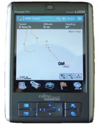
Figure A7.2: PDA with GPS
Great advantage is the option to have raster maps (orthophotos, GIS maps, georectified) shown on the display of PDAs. The software Map Calibrator (available in the Project) can georectify the maps to be used at GPS Tuner.
Waypoints and tracks can easily be transferred in different formats (kml, gpx, additionally trk for track files) to the PC to any GIS package, including Google Earth.
All PDA tracking software can be set up to work in UTM / WGS 84 (see Annex 1: Projection and datum).
More software will be evaluated during the first half of the Project, also the use of PDAs in general. Until final evaluation, the Project will use both handheld GPS and PDA.
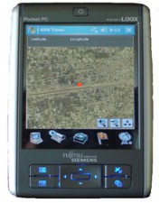
Figure A7.3: PDA with GPS
A6.3) Outlook
Personal navigation is one of the fastest-growing areas in consumer electronics. Major technological improvements can be expected within the next few years.
In future, more use will be made of the higher developed portable navigation devices (PND). They will not only be used for navigation and survey, but also to identify the name and location of the nearest facility. Navigation to locate e.g. benzin stations, hospitals, restaurants etc are already very common in many countries of the world, soon also in Ghana.
Under the umbrella of LAP, it can be envisaged to have the PND with GPS reading linked to the LSAs parcel databases, either on-line or off-line, but with real-time GPS data. The surveyor e.g. will be able to go to the location of a permit request, have the GPS read the coordinates, linking to the parcel, and showing the characteristics of the parcel on screen.
![]()
Copyright @ TCPD / LUPMP - version 2.0
Sub-Menu:
- Annex 1: Projection and datum
- Annex 2: Procurement plan
- Annex 3: Justification of procurement items
- Annex 4: Standards
- Annex 5: Possible scenarios of GIS analyses for land use planning
- Annex 6: DBMS for permits
- Annex 7: GPS mapping ←
- Annex 8: Data request for GIS
- Annex 9: Financial considerations
- Annex 10: Land use planning activities with IS
- Annex 11: Planning chart: Tasks
- Annex 12: Work programme: Tasks
- Annex 13: Pilot communities
- Annex 14: Coverage of orthophotos for LAP
- Annex 15: Training content
- Annex 16: Glossary