LUPMIS
Main menu:
- Home Page
- 1. Background and time frame
- 2. Community Orientation and GIS
- 3. Expected IS activities and output
- 4. Sites of installation and communications
- 5. Data sharing with other LSAs
- 6. Network
- 7. Software
- 8. Human resources and training
- 9. Work activities
- 10. Conclusions and future IS developments
- Annexes
- Annex 1: Projection and datum
- Annex 2: Procurement plan
- Annex 3: Justification of procurement items
- Annex 4: Standards
- Annex 5: Possible scenarios of GIS analyses for land use planning
- Annex 6: DBMS for permits
- Annex 7: GPS mapping
- Annex 8: Data request for GIS
- Annex 9: Financial considerations
- Annex 10: Land use planning activities with IS
- Annex 11: Planning chart: Tasks
- Annex 12: Work programme: Tasks
- Annex 13: Pilot communities
- Annex 14: Coverage of orthophotos for LAP
- Annex 15: Training content
- Annex 16: Glossary
9. Work activities
9) Work Activities
Technical work with data consists of a wide variety of tasks carried out at the TCPD offices. Some of them are described below.
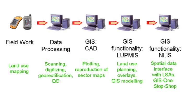
Figure 9.1: Flow of GIS activities
9.1) Collection of digital GIS data, both at HQ level and at local level: Contour lines and other topographic maps, hydrology (as lines and as polygons), administrative units (as lines or as polygons), geological maps, road / transportation units, etc. These are to be quality-controlled, checked for their scale, fit for their adequacy of information, checked wherever possible for their coordination and quality.
These digital input maps should be in geodetic reference (latitude / longitude), always based on WGS 84, and in ESRI or other compatible format (shp file or E00 format, see also Annex 8).
9.2) In particular, orthophotos or other available aerial photos (recommended: low flying, digital aerial scanning with high resolution, high quality, easy, cost-effective) or satellite images (easily available, very cost-effective, cheap) should be integrated into the IS. Amongst other, they will serve as the basis for land use mapping (see below Chapter 9.4). If not georeferenced (or georeferenced in an uncompatible system, see also Annex 1), ground control points have to be identified and image to be georeferenced accordingly.
9.3) Collection of data from field surveys, in most cases by GPS: Also, these data have to be in latitude / longitude, based on WGS 84. They can be either recorded in hardcopy (field book) or in digital format (GPS log file, route, waypoints, preferably in gpx or kml format or simple ASCII).
9.4) As a subactivity of 9.2, land use mapping and delineation will be carried out by trained staff at District level. Homogenous units will be identified and traced both in the office and in the field, and described in the field. A land use classification system will be available and serve as the basis for land use description.
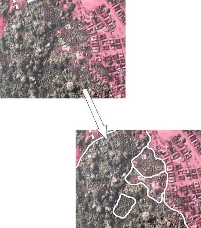
Figure 9.2: Land use mapping
Sample points will be chosen with their coordinates, and a more detailed description.
9.5) Digitization, mainly at District level: The delineation of these land use units will be entered into the GIS, by on-screen digitization of lines, which are transferred from the hardcopies, where they had been traced first. Alternatively, orthophotos with land use lines can be scanned, and then digitized from there.
Only after sufficient experience has been gained, can land use units be directly identified on-screen and traced straight from the images.
A large number of sector layout maps has to be transferred from conventional prints to digital format, by scanning and then vectorizing (digitizing). This is done at the beginning at HQ, in a later stage, when more scanners are available, also at Regional level.
9.6) Plotting is the main hardcopy output of the GIS system, at all levels. Standard routines will be developed to speed up the production of plots with templates and standard layouts, including index map, legend, scale bar, grids, title, sheet number etc.
In this stage, it is not envisaged, to print maps in standard series.
9.7) Combination of map layers with functions of intersecting, combining, excluding / cutting, etc as the basis for GIS overlays (see also Annex 5), for land use plan preparations at District level, for QC at Regional level, and for some data compilation and preparation at HQ level.
9.8) Entry of building and development permits into the Permit Database, storage and retrieval (see Annex 6).
9.9) Maintenance of the computer system, at all levels: Hardware has to be maintained, repaired, cleaned, replaced if necessary; software has to be installed and upgraded; data have to be fixed, copied for HQ and backup, etc.
9.10) Quality-control: An important activity to be carried out both at District level and at a higher level (first HQ, later Region). Data after have been entered have to be checked for data entry errors, coordinates have to be field-checked, data accuracy has to be assessed and communicated to the users, the system has to be validated, procedures have to be revised, output has to be questioned and discussed with feedback returned to the developers.
The Consultant will carry out a separate activity for this major issue and define data QC procedures. This will form a subcomponent of the entire QC, which also includes procedures to control and efficiency of land use planning in the Districts, to be carried out by the Regions.
9.11) Metadata and full documentation will be added to each new set of data.
All field work, digitization and processing of GIS data will be done in the GIS software in UTM (in meters). The advantages are the easier handling in the field by staff and clients, and the precise and reliable processing by the GIS software. It has been observed in many GIS software packages, that processing of multi-decimal values (such as latitude or longitude) can lead to significant errors.
For any applications, which require map data in latitude / longitude, these data have to be converted, which is a standard procedure.
Copyright @ TCPD / LUPMP - version 2.0