LUPMIS
Main menu:
- Home Page
- 1. Background and time frame
- 2. Community Orientation and GIS
- 3. Expected IS activities and output
- 4. Sites of installation and communications
- 5. Data sharing with other LSAs
- 6. Network
- 7. Software
- 8. Human resources and training
- 9. Work activities
- 10. Conclusions and future IS developments
- Annexes
- Annex 1: Projection and datum
- Annex 2: Procurement plan
- Annex 3: Justification of procurement items
- Annex 4: Standards
- Annex 5: Possible scenarios of GIS analyses for land use planning
- Annex 6: DBMS for permits
- Annex 7: GPS mapping
- Annex 8: Data request for GIS
- Annex 9: Financial considerations
- Annex 10: Land use planning activities with IS
- Annex 11: Planning chart: Tasks
- Annex 12: Work programme: Tasks
- Annex 13: Pilot communities
- Annex 14: Coverage of orthophotos for LAP
- Annex 15: Training content
- Annex 16: Glossary
4. Sites of installation and communications
4) Sites of Installations and Communications
4.1) Data communication and transfer between different components both
- a) between different locations of TCPD offices and
- b) between different agencies (LSAs),
have to be resolved in different stages.
Beside the administrative and political support to share data, it requires strong technical coordination carried out by TCPD-HQ (for a) and by LAP (for b). An internet protocol (TCP/IP or HTTP) will be used to establish communication between different workstations and servers for the TCPD-internal data flow (for a) and later, with guidance under NLIS, TCPD-externally under LAP (for b).
4.2) Future administration and land use planning is to be highly decentralized. A strong support of the planning and decision activities at District level has been identified as necessary, and expressed to the Consultant. It has been observed, that the actual planning work is carried out in the Districts and their Assemblies, including definition of land use zoning, field work, map production, permit requests. Therefore, to put a system in place to be used by the planners and the community, the IS should be installed at District offices of TCPD. Any other site of IS installation would risk to become unused and only for presentation purposes. Travelling to and from Regional offices is unacceptable in most cases to the District staff, for long journeys, lack of transport or funds for travelling, and limited office facilities at the Regional offices. Additionally, the location away from the Districts and their Assemblies would appeal less to the Assemblies to contribute financially to the IS of TCPD. It is therefore recommended, to place hardware, software, data, trained staff and mandate for the IS to support land use planning to the District offices.
4.3) It is also recognized, that the Regional offices have a coordinating function for land use planning. Overall coordination, quality control and more complex, but only occasionally carried out processing of data should be at the Regional offices, after the first setup at District levels.
4.4) Implementation steps will be as follows:
- Phase 1: At HQ, the systems will be installed as stand-alone, with data entry (master DB) and multiple data retrieval stations, on a PC-based system
- Phase 2: At HQ, it will be networked on a LAN server, within the same office, on a server-based system
- Phase 3: After successful testing, the system will be ported to the District offices of the pilot communities (Kasoa/Winneba, Ejisu, Asankagua, for pilot communities see Annex 13). Staff will be trained, hardware will be installed, data will be provided either from HQ or collected locally in the field. Strong technical support will be given by HQ, in form of training, trouble shooting (on-line, by phone or visits), spare parts support.
- Phase 4: Regional offices will be set up with increasing functionalities and mandate to coordinate and quality-control activities in the Districts
- Phase 5: With increasing capabilities of the Regional offices and with more Districts to work with the system, the HQ load will have to be decreased and loaded to the Regional offices.
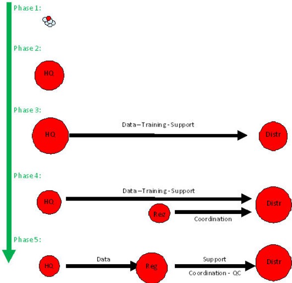
Figure 4.1: Transfer of IS activities and responsibilities between HQ, Region and District
(Observe the different sizes of circles)
In summary, the Districts have the function of collecting, entering, and storing the data, applying simple GIS analyses such as overlays, preparing the output (maps, statistics), i.e. the bulk of work. Regions have the function of coordinating and to quality-control the planning and data activities in the Districts. HQs mandate is to develop new system modifications, collect data through the national access, and to deliver technical backstopping and advice.
![]()
4.5) At this time, the installation phases explained above cannot be matched with the establishment of communications channels, because they depend on the available technology: As soon as communication facilities and bandwidth allow, the District offices will be connected to HQ, and if Regional offices are set up, also to these offices.
- Phase 1: Communication (data, software, backstopping, person-to-person) through CD or email, if available;
- Phase 2: Through a file transfer protocol (FTP);
- Phase 3: Through VPN (see Chapter 6);
- Phase 4: Through a web-based server system
4.6) To reduce the traffic, a mirror system should be set up and maintained. (A mirror databank is an identical database residing on a different server to enable faster, alternative access to external users. It has to be updated permanently or in regular short intervals).
The Consultant recommends:
Master data residing at the main activity level, i.e. at District level, if this site proves to be sufficiently equipped with hardware and manpower.
Mirror sites and backup should be based and updated regularly at HQ level, and,.
Once Regional offices are fully established, also at Regions.
Copyright @ TCPD / LUPMP - version 2.0