LUPMIS
Main menu:
- Home Page
- 1. Background and time frame
- 2. Community Orientation and GIS
- 3. Expected IS activities and output
- 4. Sites of installation and communications
- 5. Data sharing with other LSAs
- 6. Network
- 7. Software
- 8. Human resources and training
- 9. Work activities
- 10. Conclusions and future IS developments
- Annexes
- Annex 1: Projection and datum
- Annex 2: Procurement plan
- Annex 3: Justification of procurement items
- Annex 4: Standards
- Annex 5: Possible scenarios of GIS analyses for land use planning
- Annex 6: DBMS for permits
- Annex 7: GPS mapping
- Annex 8: Data request for GIS
- Annex 9: Financial considerations
- Annex 10: Land use planning activities with IS
- Annex 11: Planning chart: Tasks
- Annex 12: Work programme: Tasks
- Annex 13: Pilot communities
- Annex 14: Coverage of orthophotos for LAP
- Annex 15: Training content
- Annex 16: Glossary
5. Data sharing with other LSAs
5) Data Sharing with other LSAs
It should always be kept in mind, that data exchange is crucial not only for the implementation of NLIS at LAP, but also for all individual activities of all LSAs.
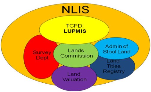
Figure 5.1: NLIS as umbrella
Once data of other LSAs become available, these should be integrated to LUPMIS. This can be done:
- At the early phases, through copying data to CD / DVD
- When technology allows, through on-line transfer (see Chapter 6 for technical details).
Standards are important to exchange data (first set of data standards to be agreed are found in Annex 4).
For example, land use planning depends on reliable maps, which are to be provided by the Survey Department. If land use planning takes place in built-up areas, also information about parcels (location, size, owner, status) has to be provided by the Lands Commission (through a unique parcel number, UPN).
Vice versa, TCPD will provide data about:
- Current land use
- Land use plans in different stages of approval,
- Approved land use
- Newly developed areas with defined parcels
- Development and building permits
to all LSAs concerned.
![]()
The Consultant recommends, that a chart of digital data flow (including mandates, agreed data standards, responsible QC agency) between LSAs should be drawn not later than at midterm of the Project.
A proposal will be made to establish a geocoding database, according to international standards, with data about locations, naming, addresses, UPN and all available properties of parcels. This can be based on geocodes or on latitude/longitude.
It is envisaged to establish a pilot phase under the umbrella of this Project.
Copyright @ TCPD / LUPMP - version 2.0