PART II: APPLICATION
4.Concept
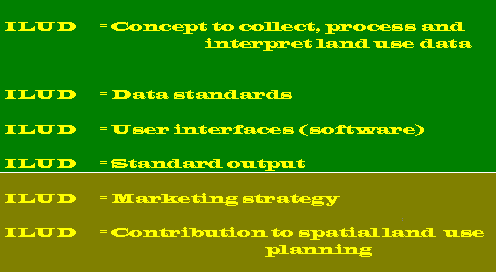
ILUD
After clarification of the objectives of the GIS at the agency BPN, a concept was defined, based on three ‘preconditions’, four ‘frame components’ where the GIS core is integrated in, and the three execution levels.
Any GIS project has preconditions, frame components and execution levels! They have to be defined during the first quarter of the project’s life span. In most cases, they will be similar to the one described here. |
The direct objective was to produce structured data in large quantities, which can be directly used for land use planning.
4.1 Preconditions
Preconditions for the concept in the project were:
This was based on early experiences made in the project. The result of the human resource assessment was the recommendation for a user interface, which can be applied at all BPN offices (see also Part 7.2).
A human resource assessment (HRA) is one of the most important tasks before setting up, selecting or developing an information system. |
Over a period of two years, with many discussions, workshops, meetings and feedback from provinces and regions, a system has been developed, which fulfills these preconditions, and which shows full viability.
4.2 ‘GIS Core’ and ‘Frame Components’
This system ILUD ('Indonesian Land Use Databank') consists - in data and software terms - of three parts:
- GIS (with Arc/Info),
- DBMS (with dBase data files and Clippperrr5 exe files), and
- remote sensing (with Erdas).
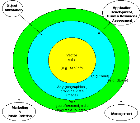
Beside these preconditions of the GIS concept (user friendliness, standardization, and performance), following components are forming an institutionalized GIS application (Fig.2):
In LREPP-II, it resulted in the development of the user interface ‘ILUD’.
Activities and data have to be made public, both within the agency and outside. New information technologies offer perfect tools. A distribution and sales policy is to be set up (see Para 7.4).
After GIS installation, this is the greatest challenge - and decisive factor for the GIS diffusion, ‘above the technical level’. It has to be necessary, that some technical expertise can be ‘carried forward to the upper management level'! While the installation of a GIS at the technical level can take months up to a few years (3 years in the described case), the management adjustment and re-arrangement of an agency to digital data flow have to be often seen as a ‘gradual process’ and easily take years .... or decades ...
All these components shown in Fig.2 have to be considered in a GIS project! |
Fig.2: Components of the GIS
(Core and Frame Components)
To perform all these requirements, it was preferred to introduce an acronym as a ‘task name’, where everybody can associate achievements and data with. In the project, it was the term ‘ILUD’, which stands for ‘Indonesian Land Use Databank’.
Obviously, in a second stage diffusion project (for implementation) particular emphasis has been given to the second and third item.
4.3 Execution Levels of ‘GIS Core’
In the GIS core, execution is done at three hierarchical levels. They are equally important, but work started from the top! The levels are related and depend on each other!
Fig.3: Levels of Project Execution
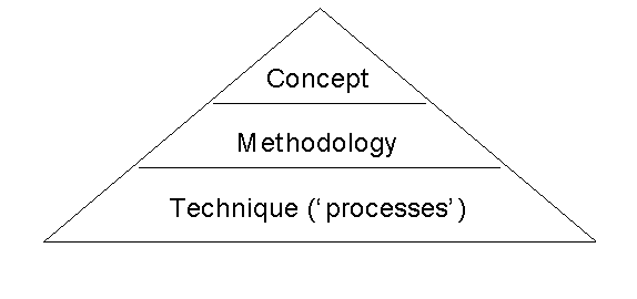
Definition of the general steps how to achieve the goal of an agency (at second or third GIS diffusion stages) or of a project (first stage). It is expressed in rather general terms such as land evaluation, mapping, land use zoning, suitability assessment. Often, it can be found in ‘ToR’ or ‘MoU’.
In this project (see Fig.4), there have been two conceptional tasks: Land use mapping and spatial land use management planning. The former was defined in the ToR and in the ‘Inception Report’ (October 1994) of the project, while the latter was more complex and defined based on the requests of BPN officials, in a process of some 10-20 discussions sessions and meetings.
More detailed than the concept, the methodology describes the steps and models which are necessary to achieve the concept. Terms such as overlay, file names, standards, land characteristics, quality control etc. can be found.
In this project (see Chapters 5 and 6), various weeklong workshops with 10 - 100 participants have been organized, to develop the methodology - and later to evaluate it, to receive feedback, and to correct it.
At the technical level, a profound hardware and software knowledge has to exist to execute the tasks defined earlier. In general, it is easier to discuss the more general aspects and more difficult to find expertise to combine the technical aspects with the required task, i.e. to make the methodology ‘feasible’ and ‘implementable’.
All levels have to be considered in a project setup and during project execution. Team members have to be aware and knowledgable. If not possible, tasks have to be assigned, staff and experience has to be recruited. |
As the project experienced, it might be possible that limitations in the capacity of the staff or of the hardware / software can result in modifications or changes of the methodology or even of the concept: An aspect, which in many GIS projects is not considered! |
ILUD is documented in a series of a 3-volume documentation:
