Information System Concept
for the Land Use Planning and Management Project at TCPD
Annex 8
Data Request for GIS
The primary data used at the LUPMIS are orthophotos (georectified, recent, flown for the Project, in georeferenced TIF format). This is used for:
- Orientation in the field (hardcopy prints, prints from GIS, display on GPS)
- Base for spatial land use identification in the field, in cooperation with the community (see
Chapter 2)
- Base for land use mapping (see
Chapter 9)
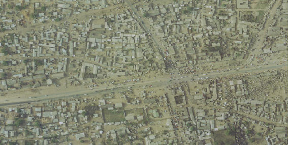
Figure A8.1: Orthophoto, 2005, location at Kasoa junction (5.534° N, 0.426° W)
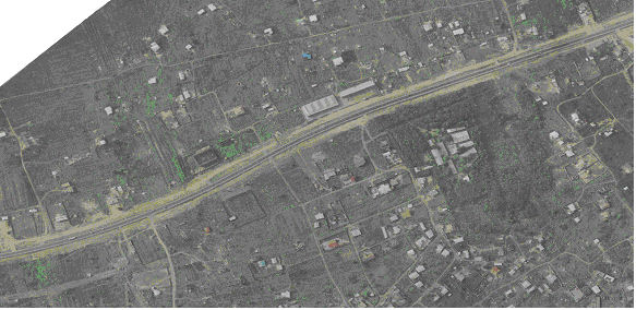
Figure A8.2: Orthophoto, 2005, location 1 km W of Kasoa junction
Auxiliary, but very important for land use planning, are following data, which have been requested and/or attempt will be made to collect them. Unless specified, they should cover all of Ghana.
- Topography: Contour lines, at the highest possible equidistance (5 or 1 m)
- Topography: Trigonometric / topographic points
- Hydrology: River lines, with drainage classes
- Hydrology: Waterbodies
- Road network (including railroad), with road classes
- Land use, whatever level of detail is available, with land use classification
- Settlements: Built-up areas (as polygons): Urbanized (5000+) including villages
- Settlements: Location of settlements / gazetteer (as points), preferably with census data 2000
- Administrative boundaries: Nation, Regions, Districts, enumeration areas etc,
- Reserved areas: Parks, reserves, protection areas, etc
- Infrastructure: Sites of schools: Primary, secondary, etc
- Infrastructure: Sites of worship: Churches, mosques, etc
- Infrastructure: Sites of water supply: Borholes, and similar
- Infrastructure: Sites of government services
- Infrastructure: Sites of medical care: hospitals, clinics, etc
- Infrastructure: Power supply, power lines, etc
- Infrastructure: Utilities (electricity, water, sewage, telephone) for selected sites, whatever is available, preferably for our first priority areas (Kasoa, Ejisu, Asankagua)
- Development: Sites of proposed development or construction, e.g. tourism, mining, roads, approved by respective authority, e.g. DA, MLFM, MoTransport, MTDA, as polygons, polylines or points
- Geology: Geology, parent material, tectonics, soil distribution (fertility, particle size)
- Digital Terrain Model
- Hillshade, if already processed
- Satellite images, e.g. QuickBird, Spot, Landsat, as far as available
- Cadastral data for our first priority areas (Kasoa, Ejisu, Asankagua)
Further data, whenever available, are useful for land use planning, and can be integrated into LUPMIS:
- Soil, with erosion hazard
- Flood risk / basin
- Traditional sacred groves
- Cemetary and burial grounds
- Places of cultural importance
- Land ownership: Stool, family, government land
- Census data with numbers about population, age, sex, household, natural growth rate, density
- Sites of industry: Major, minor, small, informal
- Market locations
- Other commercial outlets: Permanent, semipermanent
- Government offices
- Petrol stations
- Solid waste locations
- Human waste disposal: Sewerage, communal toilets
- Recreational sites and open spaces: Parks, sport, stadiums, reserves
- etc
When collecting, all data should be in standard GIS formats (e.g. vector in shp, E00 or similar formats, raster in georeferenced TIF or similar), based on WGS 84 and either in lat/long or in UTM.
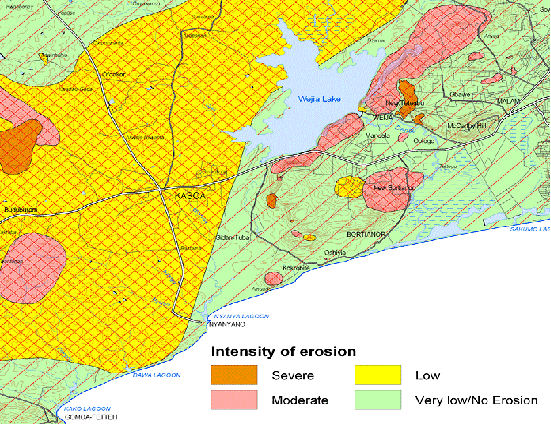
Figure A8.3: Sample of an input map for land use planning:
Erosion hazard assessment around Kasoa
(Geological Survey Dept / BGR, 2005)
Last update: Dec 2007