Figure A1.1: West Africa with the UTM grid system
There are various projections and datum definitions, which are or have been applied in Ghana and result in some confusion and inaccuracy of mapping and surveys.
One of the first datum was the Accra Datum 1929 used for the ellipsoid of War Office 1926 (also McCaw 1924), which can still be found on recent maps (e.g. on some 1:2,500 topo). Earlier maps had imperial units ('Gold Coast feet', not UK feet, equals 0.3047997 m), recent maps have metric units. The War Office projection (rectangular polyconic projection) has been defined 1853 and was mainly used in the late 19th century.
In 1977 the datum was changed to Leigon Datum 1977 used for the ellipsoid of Clarke 1880 (modified). This system is shown on some current maps (e.g. on some 1:50,000 topo), all in metric units (source)
'The problem of incompatible projections and conversion between mapping systems is of general concern to those involved in the collection of natural resources data. The Ghana National Grid (GNG) is an example of a mapping system that is not defined in image processing and GIS software and for which the transformation parameters are not readily available in the literature. Consequently, integrating GNG topographic map data within a GIS with data derived from other sources can be problematic.' (source)
The problem of having different datums was not recognized as a major problem in the past, because most GIS applications have been applied on small or medium scales, where errors due to different datums of upto 100-500 m do not show.
Agencies (LSAs) or institutes have different requirements for the tolerance of acceptable error, depending on the operating scale, either larger or smaller scales. At the NLIS, with mapping and inventories of parcels and cadastres, higher accuracy than the beforementioned of 100-500 m is required, together with high compatibility.
For map data at LUPMIS, a maximum error of 10 m can be accepted, which is derived from a compromise between projection and datum definitions, (handheld) GPS accuracy (DOP), map reading skills of surveyors, i.e. at the maximum scale of 1:2,500, and the accuracy to be expected for the tasks of TCPD. (See comments about higher accuracy options)
To be precise at that accuracy level, consistent within the NLIS, and technologically applicable, the Consultant strongly recommends to update and use a national grid (including projection and datum) as fast as possible for all mapping activities in Ghana, to be used with all GPS and on all GIS software, which is also easy to use, well documented and in accordance with international standards.
WGS 84 is the most commonly used contemporary datum, based on highly accurate and most recent measurement of the shape of the earth. WGS84 is the default standard datum for coordinates stored in all commercial GPS units (see also Annex 7: GPS Mapping). It is also incorporated in all GIS software. This will enable the professional and easy use of GPS and GIS. Many GPS do not enable the collection of data on other systems than the WGS 84.
The same system can also be applied by NLIS (LAP) and all LSAs.
Differences of point coordinates measured by different datums can amount to the range of seconds, i.e. 300 m or more, well beyond the accuracy of GPS.
The UTM system is the highest standard of projection applied worldwide, with a high level, well-defined accuracy (below 1 part in 1,000). It is easy to handle in the field due to its units of meters. Most, if not all of the neighbouring countries of Ghana use the UTM system. Introducing and implementing the UTM projection is therefore also in accordance with the other countries of the region.
In Ghana, UTM zone 30 applies (see figure A1.2 below). Beside these many advantages of applying such a precise, most up-to-date system, the only disadvantage might be a slightly higher error in the extreme East of the country, if zone 30 is applied on a national scale. On large scale, maps can easily be transferred to UTM zone 31 in these few areas in the extreme East to resolve this problem.
At TCPD, the Consultant recommends the UTM projection based on WGS 84, in order to apply a modern, adequate system, which is accurate, has not to be changed within a few years and which can easily be used by surveyors and planners in the field with GPSs.
| Projection: | (since 1926) |
(declared 1977) |
(proposed) |
| - Type: | (Gauss-Schreiber?) |
(Gauss-Krueger) |
|
| - Origin W/E (°) | -1 | -1 | -3 |
| - Origin N (°) | 4.666666 | 4.666666 | 0 |
| - Origin scale | 0.99975 | 0.99975 | 0.99960 |
| - False coords E (m) | 274,320 | 300,000 | 500,000 |
| - False coords N (m) | 0 | 0 | 0 |
| Datum (conversion to WGS 84): | Accra 1929 | Leigon 1977 | WGS 84 |
| - Shift dx (m) | -199 | -130 | - |
| - Shift dy (m) | 32 | 29 | - |
| - Shift dz (m) | 322 | 364 | - |
| - da (m) | -81.5 | -56 | - |
| - df (*10-4) | -0.255 | -0.547 | - |
| - Rotation parameter rx | - | ||
| - Rotation parameter ry | - | ||
| - Rotation parameter rz | - | ||
| - Datum scale (ppm) | - | ||
| Ellipsoid: | (RGS / mod) |
||
| - Semi-major axis (a) | 6,378,300.000 | 6,378,249.145 | 6,378,137.000 |
| - Semi-minor axis (b) | 6,356,751.690 | 6,356,514.870 | 6,356,752.314 |
| - Flattening (1/f) | 296.000 | 293.465 | 298.257 |
| - Eccentricity (e) | 0.08213004 | 0.08248340 | 0.08181919 |
| - 2nd eccentricity (e) | 0.08240845 | 0.08276543 | 0.08209444 |
Table A1.1: Projection, datum and ellipsoid parameters
Figure A1.1: West Africa with the UTM grid system
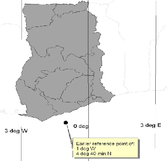
Figure A1.2: Ghana with UTM zones
In an interim period, until final decision has been made, data will be collected in the field and stored in the GIS system, using the latitude / longitude system or the UTM 30 projection, but all based on WGS 84 (comment).
The coordination conversion package Geographic Transformer to convert to / from different projections and datums is highly recommended for the ease of its use.
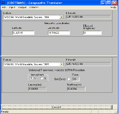
Figure A1.3: Screen of software for coordinate conversion
This software has been 'fudged' (i.e. adjusted based on empirical error minimization, see additional parameters), but research still takes place (as of October 2007) to adjust the conversion to / from War Office definition in precise, geodetic terms. Alternatively, different conversion software with predefined War Office conversion has to be searched for, and procured, to enable - at least in the interim period - a conversion from collected GPS coordinates to the War Office system to be done with the expected accuracy.
On 13 October 2008 the Survey Department announced that starting from 2 January 2009 all maps and plans within the Golden Triangle (Accra - Takoradi - Kumasi) should be in WGS 84 / UTM. It also published three different parameter sets for conversion from War Office to WGS 84 (see below). Testing which of these sets is the preferred one will follow in the project.
At this moment, such a conversion to use GPS readings with the available maps is not possible.
Latest research proposes following parameters for conversion from War Office to WGS 84:
(Molondenski) |
(Helmert/Bursa-Wolf) |
|
| Datum conversion to WGS 84: | ||
| - dx (m) | -196.24 | -145.95 |
| - dy (m) | 33.38 | 31.45 |
| - dz (m) | 322.76 | 327.94 |
| - da (m) | -163 | |
| - df (*10-5) | -2.5567 | |
| - rx (rd, *10-6) | 1.443 | |
| - ry (rd, *10-8) | -1.193 | |
| - rz (rd, *10-9) | 5.383 | |
| - Datum scale | 0.999992069 | |
| - Ellipsoid | ||
| - Projection |
Table A1.2: Conversion parameter proposals
Following parameters are given by Survey Department for conversion from War Office to WGS 84:
| Datum (conversion to WGS 84): | |||
| - dx (m) | -196.557 | -158.635 | -196.580 |
| - dy (m) | 33.385 | 32.174 | 33.383 |
| - dz (m) | 322.452 | 326.783 | 322.552 |
| - da (m) | |||
| - df (*10-5) | |||
| - rx (rd, *10-7) | 1.786 | 1.786 | |
| - ry (rd, *10-8) | -3.872 | -3.872 | |
| - rz (rd, *10-8) | -5.767 | -5.767 | |
| - Datum scale | 0.9999940 | 0.9999924 | 1 |
| - x0 | 6339239.290 | ||
| - y0 | -120750.511 | ||
| - z0 | 686012.361 |
Table A1.3: Official, but provisional parameters by Survey Department
(Remark about this Annex)